
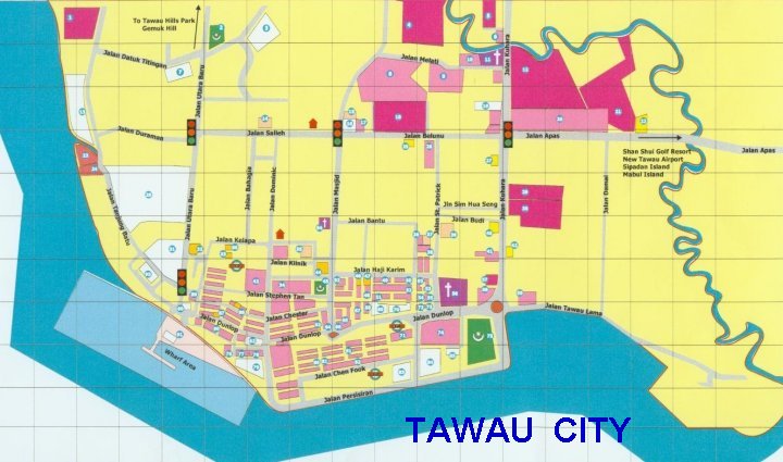
Maps of Tawau Town
and surrounding areas and places of interest
Maps of Tawau Town
and surrounding areas and places of interest
Tanjung Batu Laut Timber Complex
Tawau


Jalan Tanjung Batu Laut
(Tanjung Batu Laut Road)


Maps Revealing the lost world of Borneo
In 1947, a pilot flew from the west coast of Sabah to Tawau narrowly avoided
colliding with a wall of steep cliffs. This incident is the first recorded
mention of the Maliau Basin....

Direction Map to Tawau Hot Spring
1024 x 1344 183KB

Direction to Calvary Church and Buddhist Lodge in Tawau

Map of Cocos Island
The Island where Orang Cocos originally
from.
Cocos (Keeling) Islands, is a territory of Australia. There are two atolls and
twenty-seven coral islands in the group. The islands are located in the Indian
Ocean, about one-half of the way from Australia to Sri Lanka.

Road map to Al-Kauthar Mosque, Sabah largest mosque

Including this
Tracking Map of Tawau Hills Park Showing the direction to Sulpher Spring
(Hot Sprint) and Bukit Gelas Water Fall


Location map and Road Map to
Imbak Canyon Conservation Area on North-West of Tawau


Location map of the 5 islands of Tunku Abdul
Rahman Marin Park in Kota Kinabalu
1 - Police Beach 2 - Sapi Island 3 - Gaya Island 4 - Manukan Island 5 - Sulug
Island 6 - Mamutik Island

Location Map of National Parks of Sabah
This map show location of Tawau Hills Park, Danum Valley, Maliau Basin, Tabin,
Sg. Imak, Kinabatangan, Kulamba, Sukau etc.
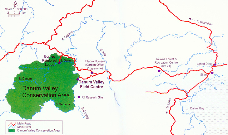
MAP OF Danum
Valley Field Centre
Danum Valley Field Centre has a wide range of facilities besides visitor
accommodation, such as scientists' quarters, laboratories, library, computer
room with 'broadband' services, conference room, environmental education
building with classroom, multi purpose hall, public telephone, research plots
and over 50 kilometers of marked trails..........

Kinabatangan Wildlife Sanctuary is one of just two known places in the world to
be inhabited by ten species of primates, four of which are endemic to Borneo.
This map show you the location of
Sukau Rainforest Lodge


Map of Mataking Island
Showing surrounding islands of Mabul Island, Sipadan Island ...
RELATED TOPICS
|
|
PLACES OF INTEREST |
