
ISLANDS OF BORNEO > Sabah Islands >
| ENGLISH VERSION | CHINESE VERSION 马努干岛 |
Manukan offers clear waters and beautiful coral reefs. Shaped like a
dolphin, the island is 1½ km long. Blessed with a long stretch of white
sandy beach promising hours of sea, sand & fun! Guests can choose to stay in
one of the single or double storey chalets. All chalets overlook the South
China Sea and a spectacular sunset is almost a daily affair.
The island is also ideal for small to medium sized group meetings. Have a
solitary time for yourself at the Look-Out Point and watch the beautiful
sunset of Borneo.
The island is accessible from downtown Kota Kinabalu by boat. Journey takes
about 20 minutes from the jetty of Jesselton Point (formally the location of
Sabah Port Authority)
Pulau Manukan is located off the coast of downtown Kota Kinabalu.
There are a number of tour operators provide day tour to Tunku Abdul Rahman
Marine Park (which consists of the islands of Pulau Gaya, Pulau Sapi, Pulau
Manukan, Pulau Sulug and Pulau Mamutik).
Manukan Island Package
:
Almost all hotel offer or help arrange Day Tour to TAR Marine Park. Manukan
Island is the most popular island because of its well developed tourist
facilities.
Just ask your hotel counter for information for an Island Day Trip.
The second largest island in Tunku Abdul Rahman Park.
Manukan is the most popular island. It is covered in dense vegetation and
has hiking trails.
Good stretches of beaches are on the southern coastline of this island. The
best beach is on the eastern tip. Manukan has rich coral reefs ideal for
snorkelling and diving.
Out of 5 islands in the park , Manukan has most developed tourist facilities
that includes:
1) a resort with 20 units of chalets
2) a clubhouse
3) a few restaurants
4) a diving centre.
Recreation facilities :
1) a swimming pool
2) football field
3) squash and tennis courts.
Manukan Island has a Marine Conservation and Research Centre, it also had
some attractions such as "Remnants of World War II".
Infrastructural facilities include :
1) Water
2) Electricity
3) Desalination plant
4) Sewerage system
This 51 acres boomerang shaped is the second largest of the Tunku Abdul
Rahman Park, Manukan has good stretches of beaches on the southern
coastline. There is a trail system around the island. Ideal for snorkeling,
diving and swimming. The snorkeling area is far left of thebeach. Snorkeling
at Manukan is fantastic! The variety of marine fish is astounding. The
corals were of great varieties too
Accommodation in Manukan Island :
1. Hilltop Lodge (Single Storey) 4 Units
2. Hilltop Lodge (Double Storey) 6 Units
3. Beach Lodge (Single Storey) 4 Units
4. Beach Lodge (Double Storey) 6 Units
Contact Information
Sutera Sanctuary Lodges (392937-K)
Sales & Reservation Office:
Lot G15, Ground Floor, Wisma Sabah
88000, Kota Kinabalu, Sabah, Malaysia.
Tel : (60-88) 243629 Fax: (60-88) 259552
Leap - 123 Jump!

This delightful seaside, how many people
eagerly longing to come. So be sure to make a leap for memory of this
beautiful bright moment!!
blog.yam.com/dayancat716

www.sabahtravelguide.com/mapguide
How to get to Manukan Island
Getting to any island of Tunku Abdul Rahman Marine Park is easy. Just take a
boat ride from Jesselton Point where there are several ticketing counters
from different travel agents selling packages such as island hopping, sunset
cruise, diving and beach activities and even packages inclusive of meals.
The pricing are more or less the same. For a trip to Manukan Island, the
cost is a total of RM 22.00 per person.
The history of the harbour is also shown in black and white pictures placed
on the walls and outside the Jesselton Point ferry terminal.
Bird Watching & Nature Trail
BIRD WATCHING: There are some special species to note here such as the
island-dwelling Pied Hornbill; and the interesting Megapode. Between
September and April, large flock of terns and other migrant waders can be
seen resting on the sandbar at low tide.
NATURE TRAIL: Trek to Sunset Point. The trail passes along cool lowland
forest. The occasional Pangolin or Scaly Ant-eater and monkeys may be seen
along the trails. Quiet picnickers may be visited by large Monitor lizards
in search of a few scraps.
What are available in Manukan Island
Pulau Manukan Island is a 15-20 minutes boat ride from Kota Kinabalu
city
The Four highlights in Manukan Island
1/4 : Coral beds & Dive Sites

20 different dive sites in Tunku Abdul Rahman Marine Park
The reefs lie in shallow waters with little current making it an ideal
location for novice divers, however, the diverse and sometimes rare marine
creatures also make it an interesting dive location for experienced divers
and underwater photographers.
2/4 : White Sandy Beach

Good stretches of beaches on the southern coastline.
The best stretch is on the eastern tip of the island. Crowded during
Malaysian school holidays.
Ideal for snorkelling, diving, swimming and fish feeding.
3/4 : Public Facilities

Basic tourist facilities are provided on the beach:
Water-based activity centre for renting kayaks, snorkelling gears,
life jackets, etc
A number of cafes,
3 restaurants,
Souvenir shops,
Water sports,
Hiking trails,
Camping,
Exhibition hall by Sabah Parks,
The Sabah Parks Marine Headquarters,
Washrooms with showers,
Dive centres.
4/3 : A Beach Resort

Manukan Island Resort
is operated by Sutra Sanctuary Lodges.

Photo above : Western stretch of beach of Manukan Island is
usually crowded. But The best stretch of beach is on the eastern tip of the
island a walking distant away on a walking trial.
The island has very clear waters and is an excellent venue for water-skiing
and sea-sports. The beach however is somewhat rocky and swimmers should
exercise some caution.
There are coral beds on the eastern and the western reefs and multicolored
coral fishes abound here.


Manukan Island - an ideal getaway for a short break
from the city.
This shade-fringed island offers modern chalet accommodation,
restaurants, and a swimming pool. A white sandy beach and fringing coral
reefs teeming with marine life beckons the city-frazzled nature lover to
swim, snorkel, dive and just unwind...

The beach at Pulau Manukan
is less spectacular to Pulau Sapi, but people come to Pulau Manukan
for the diving and snorkeling.
Its shortcomings above the water surface is compensated by the rich and
colourful marine life underneath it.


Open air kitchen under shady trees
Manukan has most developed tourist facilities that includes a few
restaurants. The Manukan Island Restaurant offers a wide selection of
cuisine or visitors may make pre-arrangement for barbecue.
A full day Island picnic tour package with Grilled BBQ is available for
booking through hotel counter or tour argent.


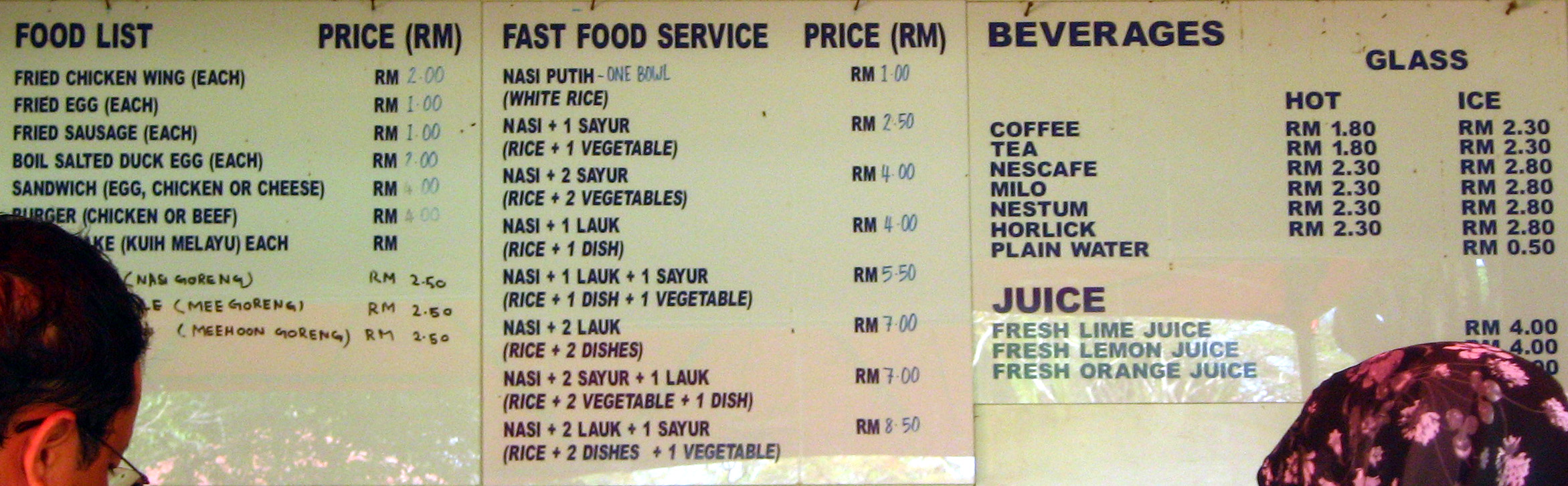
THE BEST SELECTED ISLAND MENU
FRIED NOODLES RM 18.00nett
ROASTED CHICKEN RICE RM 18.00nett
ISLAND BURGERS RM 24.00nett
FRIED CHICKEN WINGS (1/2 Dozen) RM 16.00nett
CHICKEN SATAY (1 Dozen) RM 18.00nett


FISH FOOD RM3.00
Enjoyed snorkelling with fish feeding followed by hundreds of fish
when they see your bottle of food for them.
You also find nemo here.

SWIM EQUIPMENT FOR RENT
On the island is a store to rent snorkelling equipment.
You can rent equipments at the island itself, or rent from the tour boat at
a cheaper price. Deposit required.
|
SEASPORT RENTAL |
PRICE | DEPOSIT |
| MASK, SNORKEL & FINS | 15.00 | 50,00 |
| MASH & SNORKEL | 10.00 | 40.00 |
| MASH ONLY | 10.00 | 40.00 |
| FINS ONLY | 10.00 | 40.00 |
| SNORKEL ONLY | 5.00 | 20.00 |
| BEACH MAT (SMALL) | 4.00 | 5.00 |
| BEACH MAT (LARGE) | 5.00 | 10.00 |
| LIFE BUOY | 5.00 | 10.00 |
| LIFE / TUBE RING (SMALL) | 5.00 | 10.00 |
| LIFE / TUBE RING (LARGE) | 6.00 | 10.00 |
| LIFE JACKET | 10.00 | 20.00 |
| BODY BOARD (SMALL) | 5.00 | 10.00 |
| BODY BOARD (LARGE) | 10.00 | 15.00 |
| BALL (VOLLEYBALL / FOOTBALL) | 5.00 | 50.00 |

For those who do not want to join an expensive picnic package but came by own arrangement, there is an economy food outlet on this island.

RELATED TOPICS
|
|
Islands |