
eTawau > Places of Interest in Tawau District > Tawau Hills Park > Bombalai Hill
A dormant volcano an hour's walk from the Tawau Hills Park car park — and you do not need a ticket to climb it
Bombalai is a volcano. It is dormant — the last activity is reckoned in thousands of years, not centuries — and at the top there is a crater about 300 metres across, breached on its southern side. The hill stands about 531 metres above sea level.
It is the most accessible volcanic cone in Sabah, and one of very few places in Malaysia where an ordinary walk of under two kilometres takes you to the rim of one.
You do not enter the park gate and you do not buy a ticket, because Bombalai Hill is outside the park's entrance. From the outer car park — not the inner one — walk towards the end of the road, where a plantation road begins along the boundary of the park. That plantation road is the start of the climb.
The 1.9 km divides into two quite different kilometres, and the difference is the most interesting thing about the walk.
Bombalai Hill and Tawau Hills are both protected forest, and they have been broken apart by that one kilometre of plantation. Walking it, you pass from one ecology to the other in a few minutes, and you can see exactly what the separation looks like on the ground — and, now, the first signs of it beginning to close.

In recent years the rules have changed what may grow along that edge. The plantation road runs inside a 50-metre buffer zone along the boundary of the protected forest. Land in the buffer that used to be private oil palm is no longer replanted with oil palm when the old palms come to the end of their life. It is set aside and left to grow back naturally to forest.
In Sabah the 50-metre figure comes from the environmental conditions that the Environment Protection Department (EPD) attaches to oil palm plantations that have gone through an environmental assessment — an Environmental Impact Assessment (EIA) or a Proposal for Mitigation Measures (PMM) — under the Environment Protection Enactment 2002 and its Prescribed Activities (Environmental Impact Assessment) Order 2005. EPD's guideline for plantations on meeting those conditions sets out what is expected:
For a walker, the result is simple. The first kilometre of the Bombalai walk is now a place to watch plantation turn back into forest. Over the coming years the gap between Bombalai and Tawau Hills along this edge should narrow, and the insects and plants recorded on this stretch are a record of that change while it happens.

The bearded pig was not a protected animal in Sabah before 2021. Then African Swine Fever swept through and the population collapsed, and in 2021 it became a protected species for the first time in the state's wildlife history.
The school's animal farm where that photograph was taken is on the Kuhara Road route to Tawau Hills Park. The zoo itself was closed by the Sabah Wildlife Department on 17 September 2015 after animals were found in squalid conditions; some common, easily kept animals remain, and it is still open as a domestic-animal zoo for a small fee. Do not expect the rare animals you would hope to see in Tawau Hills Park.
The 900 m of jungle trail is marked, and it is photographed here mark by mark — so you can see before you go what you are walking into.


Field records made on the Bombalai Hill trail and published on this site:
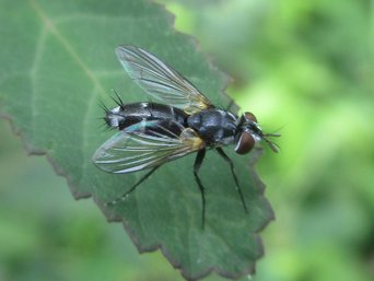
17 September 2026, 10.11 in the morning. A grey-and-black fly with long, stiff bristles on its
abdomen — superfamily Oestroidea, the blow flies, flesh flies and tachinids, probably a tachinid — on a
leaf beside the plantation road, inside the 50-metre buffer.
It landed, stayed a few seconds and flew off; one photograph.
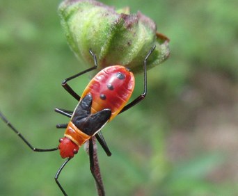
17 September 2026. A bug about 14 mm long — Dysdercus sp., Pyrrhocoridae, a nymph — on the
flower buds of a mallow shrub in the first few hundred metres, on the plantation road.
One or two on every plant, and the plant common along the verge. The commonest insect on the walk
lives on the half of the walk that is not forest — yet.
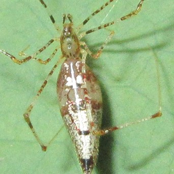
9 October 2026, about five in the afternoon. A spider of about 10 mm — Rhomphaea sp., Theridiidae — hanging
on a silk line below a leaf a little past the 400-metre mark of the jungle trail, swinging in the wind like
a scrap of debris. A very thin web under the leaf was its retreat. When the leaf was held still for a photograph it would
not keep still itself.
Photographs and field observations by Wong Fook Yee. The trail sequence was photographed in 2017 and
the view of the hill in 2006; the bearded pig was photographed in 2005 at Yuk Chin Primary School,
Tawau.
A correction made in this rewrite. The earlier version of this page gave the height
of the hill as 540 m in one place and 530 m in another. The published figure for Mount Bombalai is
about 531 m, so the lower of the two was right; the page now gives one figure
throughout. The crater — about 300 m across and breached to the south — is added here for the first
time. All photographs © Wong Fook Yee. Page rebuilt 17 September 2026.
The 50-metre buffer section was added on 1 October 2026. Sources: Environment Protection
Department Sabah, Environmental Self-Regulation (ESR) Guideline in Compliance with Environmental
Conditions for Oil Palm Plantations in Sabah (first published 2019), which sets the forest
reserve buffer (minimum 50 m), the Sabah Parks buffer (50 m or more), the riparian buffer and the
restoration of palms already planted in a buffer; and, for river reserves in Sabah, the Sabah Water
Resources Enactment 1998. The situation on the ground along this road is the photographer's own
observation.